
York LCWIP

City of York Council adopted a Local Cycling & Walking Infrastructure Plan (LCWIP) last month.
The LCWIP’s Cycle Network Plan shows:
- the Strategic Cycle Network in red and
- the Local Network in blue
The network was drawn up using the Propensity to Cycle Tool (PCT), and with the help of transport consultants Systra.
The Strategic Network has been split up into 68 routes. They were sifted and prioritised based on:
- safety issues
- health and environment
- replacing short car journeys
- addressing resident feedback in consultations
This resulted in a Top 12 cycle route projects which are considered to have significant value for the city:
- Malton Road – Heworth Green – Monkgate – Lendal Bridge – Leeman Road
- Bootham Bar – Clifton (Rawcliffe Lane)
- Ouse Bridge – Micklegate – The Mount – Tadcaster Road – York College
- Micklegate Bar – Blossom Street – Holgate Road – Hamilton Drive
- Monks Cross – Malton Road – Heworth Green – Monkgate
- Station – Lendal Bridge – Gillygate
- Tang Hall Lane – Foss Islands Path – Hungate – Aldwark – Lord Mayor’s Walk
- Acomb Road
- Tang Hall Lane – Foss Islands Path – Hungate – Ouse Bridge – Station
- Copmanthorpe – Tadcaster Road – Station
- Water End
- Water End to Skeldergate Bridge via Cinder Lane to Skeldergate Bridge
These priorities will be turned into a pipeline of schemes.
Longer distance routes into York would be a matter for the Combined Authority.
The council plans to do three demonstrator schemes:
- one radial route
- one suburban route and
- one village link
Infrastructure improvements being considered include fully segregated cycle tracks, cycle lanes with light segregation, reduced speed limits, reallocation of road space away from motor vehicles, barrier removal, advance cycle phases at busy junctions, cycle priority over side roads and path widening.
Vision and Measures
The vision is to make cycling more attractive as an alternative to the car. This will require a continuous network of high-quality cycle routes.
As well as building cycle tracks, the council intends to improve cycling facilities during routine highway maintenance, put in new crossings and adjust timings to give cyclists more priority, create School Streets and reduce speed limits.
Alignment with Other Policies
The LCWIP is intended to align with other policies.
Local policies include those set out in the Local Transport Strategy and Movement and Place Plan Framework. In this context, the LCWIP says:
‘If we are to see a return to the levels of walking and cycling that we once took for granted, we need a major reallocation of road space to sustainable travel, as well as significant investment in active travel infrastructure, development of the skills required to effectively and sensibly implement new and improved routes, plus a strong level of engagement and community support to ensure the whole city can benefit’.
The LCWIP also fits in with York’s Hierarchy of Road Users.
National policies include Gear Change, LTN 1/20, Manual for Streets, Inclusive Mobility, Healthy Streets and CWIS2.
Walking and Wheeling
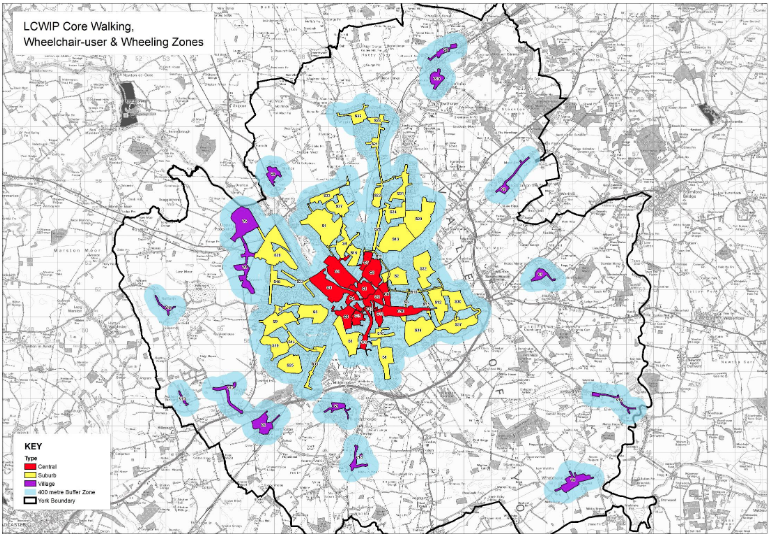
The LCWIP also has a walking and wheeling element, and 65 zones have been identified. They are split into:
- central
- suburban and
- village
The zones will be assessed using a Healthy Streets approach, and steps taken to make them more accessible, safe and attractive.