
Design Options for the Oatlands Area
This post follows on from Oatlands Consultation Shows Most Respondents Unhappy and Want Change.
That first post reported the results of traffic surveys and a Commonplace consultation. Now I will look at the designs proposed by consultants WSP. The numbering follows on from the original post.
3) Context and Options
The Context and Options section of the WSP report reminds us that Oatlands Drive is an important route on NYC’s Harrogate & Knaresborough Local Cycling & Walking Infrastructure Plan (LCWIP).
The LCWIP was also written by WSP, and their work was complete by 2019. It included detailed designs for four routes.
Since 2019, NYC have made no attempt to implement the LCWIP and build the routes.
The LCWIP is described as the ‘planned network’, but in reality NYC have no plans to build it. The LCWIP was done purely so that they can say ‘yes we’ve got an LCWIP’. The documents that make up the LCWIP are only for decorative purposes.
Possible Measures
The Context and Options section runs through which measures might be included in designs:
- segregated cycle lanes on Oatlands Drive (‘there may be space’ and 175m2 of Stray land would be needed)
- create space for cycle tracks by making Oatlands Drive one way
- modal filters (traffic filters)
- banning some turns to make Oatlands Drive less attractive as a through route
- soft measures like school travel planning
- School Street (unlikely to be practical)
- parking restrictions
- speed reduction measures
WSP says of the one-way proposal that it was ‘not supported by residents during consultation’, but in fact it was never put to residents in a consultation.
The first consultation was on the location of ATF2 schemes only, and the one-way scheme had been abandoned by the time of the second consultation.
Of speed restrictions (20mph and traffic calming), WSP say:
‘This would improve road safety but is unlikely to address issues identified in the engagement survey around too much traffic, unsafe to cycle and too much parking (unless introduced alongside other measures)’.
Wsp comment on 20mph, p28 of the summary of issues and ideas report
Objectives of the Proposals
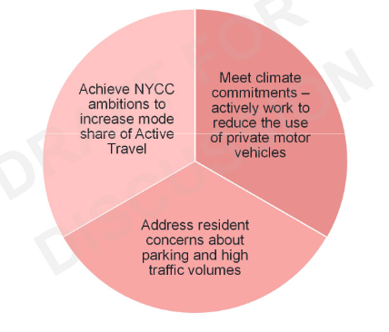
WSP say that NYC’s objectives are:
- to increase mode share of active travel
- to meet its climate commitments
- to address resident concerns about parking and high traffic volumes
NYC is prepared to say the right things about active travel and the climate, but in reality it is not committed to doing anything about either issue.
If you look at the council’s actions over an extended period of years, they show that it is committed to prioritising motor vehicles and preserving the status quo.
What Do People Really Want?
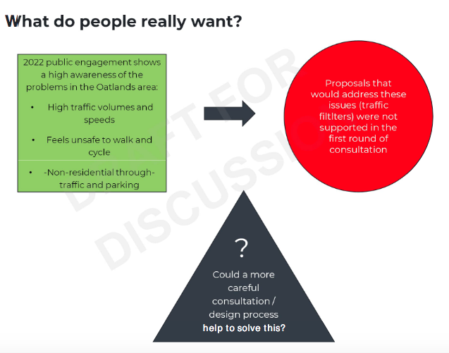
The WSP graphic above shows the conundrum: people identify the harm caused by high traffic volumes, but when you put forward proposals that would resolve the problem, there is furious opposition from at least some respondents.
There will never be consensus but if you forge ahead with a good scheme, most people will see that it works and support what you did. That is what has happened in Waltham Forest.
We need a council with a strategy to limit motor vehicle access and prioritise active travel, and the backbone to implement it despite some opposition. Unfortunately, we have North Yorkshire Council.
4) Current Design Options
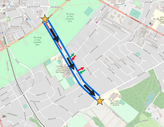
Option 1 One-Way Proposal

This was the original design that won Active Travel Fund 2 (ATF2) funding in 2020. By making Oatlands Drive one way for motor vehicles, it creates space for protected cycle tracks without loss of Stray land.
From a cycling point of view it is the best design.
Again, WSP say it is ‘not supported by local residents’, but in fact it has never been put to consultation.
Option 2 Do Minimum
Option 2 was put to consultation in 2021.
It involves removing parking on Oatlands Drive, and making St Winifred’s Road entry only and St Hilda’s Road exit only. There would be speed bumps.
It doesn’t really change anything in a meaningful way, and it is hard to see the point of the junction changes to St Winifred’s and St Hilda’s.
WSP say:
‘Does not significantly improve conditions for active travel. Unlikely to lead to mode shift towards walking and cycling’.
p36 of the wsp summary of issues and ideas report
5) New Ideas
Now WSP put forward some new design options.
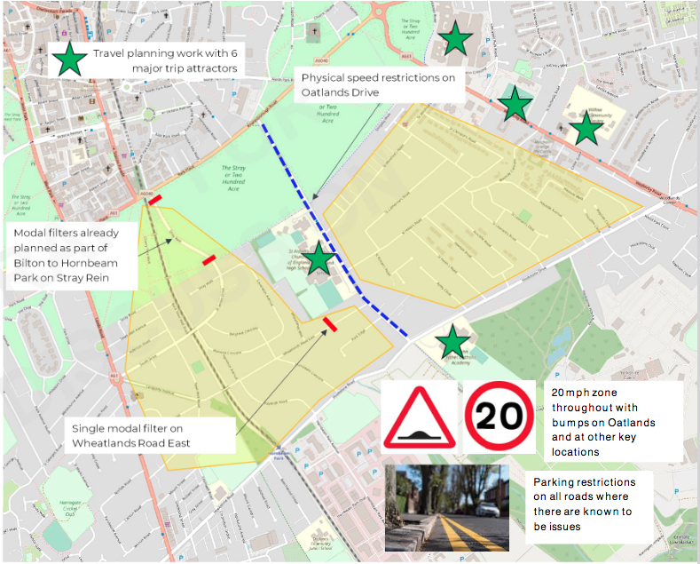
Option 3 Segregated Cycle Tracks and Two LTNs
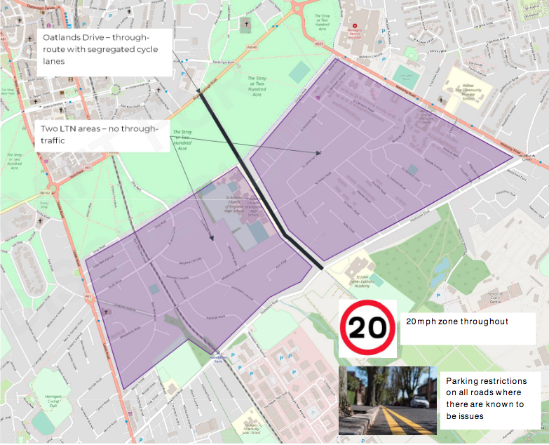
WSP think they can fit in cycle tracks either side of Oatlands Drive without making it one way for motor vehicles. Are they right?
There would also be:
- Low Traffic Neighbourhoods either side of Oatlands Drive
- 20mph throughout and
- parking restrictions on side roads where there are known to be issues
Option 4 Single Large LTN
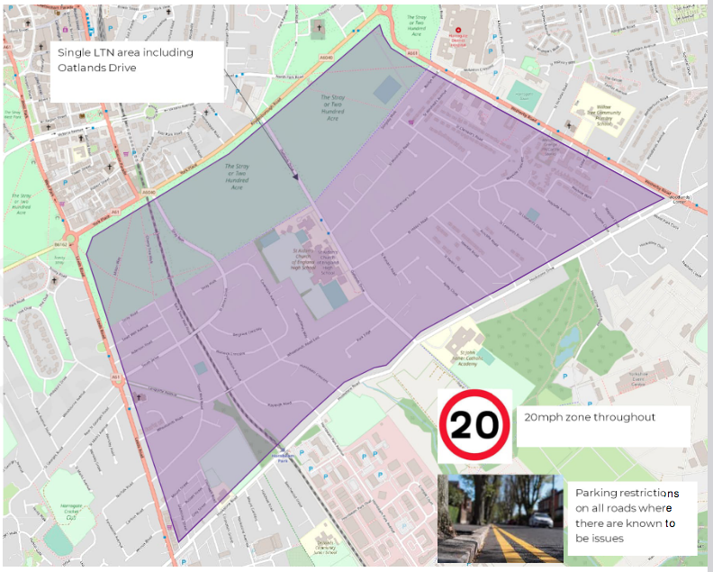
This design option would prevent all traffic using the area as a through route.
The result would be much lower traffic volumes and speeds, which would make it safer for walking and safe for cycling.
Option 5 Do Minimum
Option 5 Do Minimum is similar to Option 2 Do Minimum.
There would be no dedicated cycle provision, and no modal filters on Oatlands Drive, so traffic would remain at around 9,000 vehicles a day.
The measures would include:
- 20mph and traffic calming
- parking restrictions
- modal filters on Stray Rein ‘already planned’. (These modal filters are in the LCWIP, but since NYC is an irresponsible, do-nothing council, it has no intention of putting modal filters on Stray Rein)
- modal filter on Wheatlands Road East
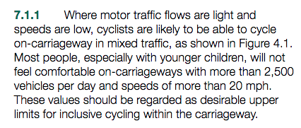
As with Option 2, Option 5 would not significantly improve conditions for active travel; it would not comply with LTN 1/20 Cycle Infrastructure Design because people on bikes would be cycling in relatively heavy traffic (around 9,000 vehicles a day).
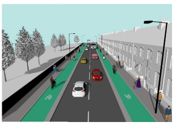
Is Option 3 Viable?
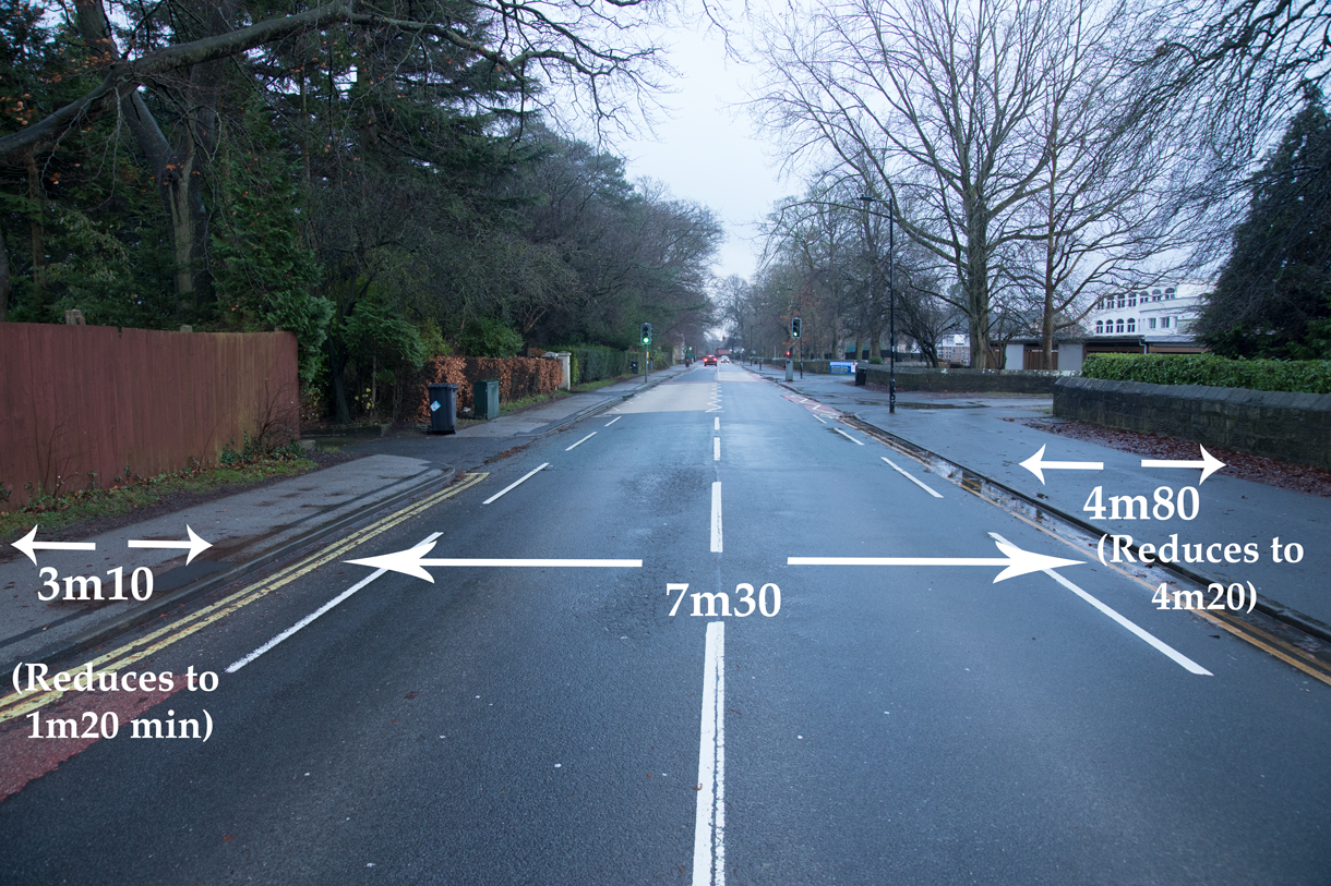
Is Option 3 – dedicated cycle tracks without making Oatlands Drive one way – viable? Is there enough space?
For one-way cycle tracks, you’re looking for 2m either side (Desirable Minimum) or 1.5m (Absolute Minimum).
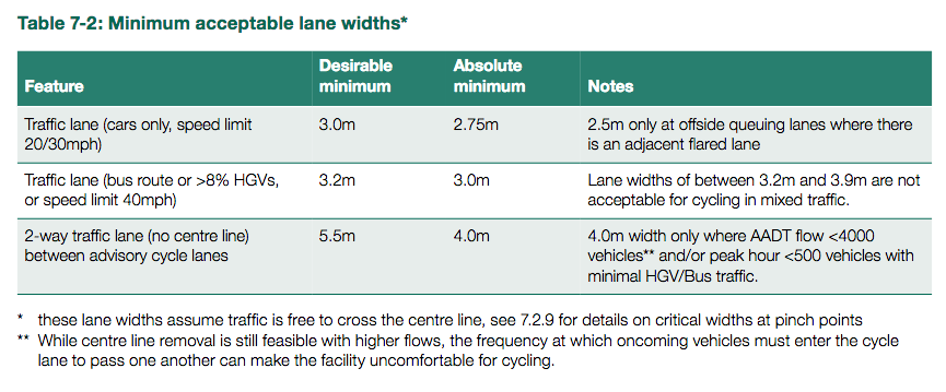
Can you take any carriageway space? Maybe a little bit – Oatlands Drive could perhaps be reduced to 6m Absolute Minimum, given that school buses use it.
The rest of the space would have to be taken away from pedestrians, which is far from ideal.
Option 1 One-Way Proposal is better than Option 3 for these reasons:
- it reallocates space from private motor vehicles, not walking
- this helps meet the council’s supposed goals to increase active travel, decrease car miles, and decarbonise transport
- the carriageway space freed up could be converted to cycle tracks far more easily and cheaply; Option 3 is likely to be complicated and expensive